On this page you’ll find a gallery of local images.
We’ll be adding more images to this page, so please keep checking back. We’d also be interested in any photographs (or other documents) you might have of Brimington and Tapton – please contact us.
Unless credited all images are from the local history group’s collection or from our members.
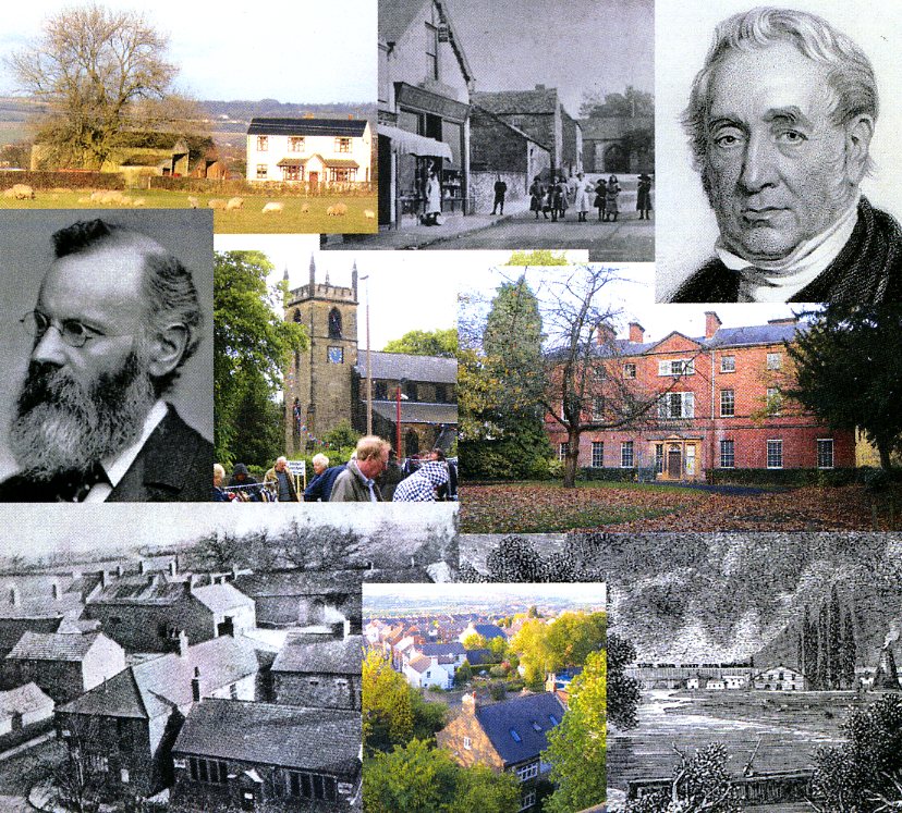
We have chosen the illustrations on our home page to represent Brimington and Tapton. To start our gallery, we’ll take a look at these pictures (1 – 7) and explain why they are included.
The two ‘famous faces’ are (top right) George Stephenson (the ‘father’ of the railways, who lived at Tapton House) and Henry Bradley (middle left), a leading light in the Oxford English Dictionary, who lived on Brimington Common, during his younger years.
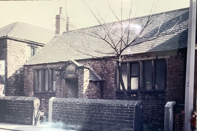
1) Bradley’s father worked for John Knowles, who operated a blast furnace on the Common at what is now known as Furnace Farm (pictured here in February 2018) in the 1850s. You can find out a lot more about Bradley and the furnace in the article on Henry Bradley here, originally published in Brimington and Tapton Miscellany. (Philip Cousins).
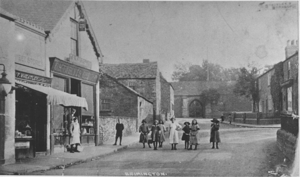
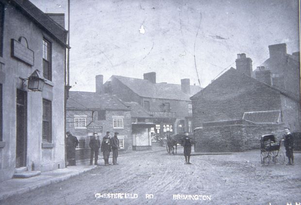
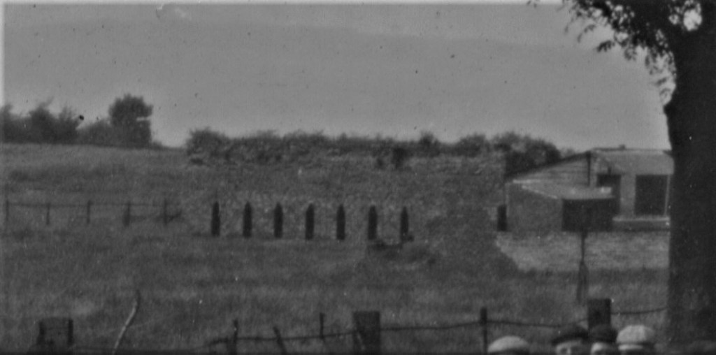
2) An Edwardian view of High Street Brimington. In the distance is the archway entrance to Brimington Hall, demolished from the 1920s onwards. This Jacobean mansion was a sad loss to the village when it was demolished. To the extreme right is the wall to the parish church burial ground, which was removed and built further back in the 1920s as road traffic increased. Further on are a block of stone houses which still survive. To the left is Wheatley’s sweet shop, followed by Twelve’s chemist shop, beyond is Church Farm, now replaced by a petrol filling station and fast food outlets. Turning to the left, at the end of the buildings, would lead onto the bottom of Manor Road – an area called Pondwell Corner, as there was a pond there.
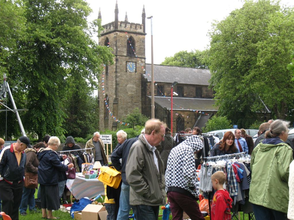
3) A modern view of the parish church taken at the annual village gala in June 2012. Brimington was created a separate parish in 1844, until this time it was a chapelry of Chesterfield Parish Church. It became a civil parish in 1898. This is probably the third building on the site of the existing. There was an earlier chapel, with a tower added to it in 1796. This chapel was replaced by a new building in 1808. The tower was retained. In turn, another larger building – the present church – was opened in 1847. The tower was raised and remodelled at this time. You might be able to see the site of an earlier clock on the tower masonry. The village market was replaced in 2024 by a much larger ‘Brim Fest’ held on Eastwood Park, Station Road. (Philip Cousins).
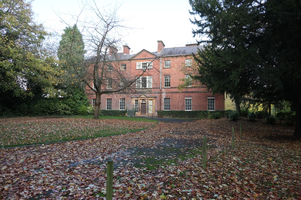
4) Tapton House, in November 2020. Best known as the last home of George Stephenson, who died there in 1848 – probably in the bedroom above the entrance. We have also researched about George Stephenson’s third wife – his former housekeeper – in our Brimington and Tapton Miscellany 6. For details on how to obtain this see our publications page. We’ve also a blog on how Stephenson promoted the invention (by a Nottingham man) of the steam pressure valve by installing an example at his Tapton (later Lockoford) Colliery. See our blog here for further information. (Philip Cousins)
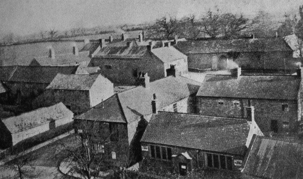
5) This is a view from Brimington Parish Church tower looking towards the gated entrance of Brimington Hall. Photograph (3) was taken from street level a little further back from the bottom left of this photograph. Church Farm is to the left, with Pondwell Corner beyond. To the bottom right is the former National School opened in 1840. It was superseded by the buildings of the Brimington United District Board Schools built on Brimington Common and Devonshire Street in the 1870s. It was demolished in the 1970s. The buildings to the left and behind the National School still survive as dwellings. Although this image appeared in Vernon Brelsford’s 1937 ‘History of Brimington…’, it must actually date from the 1920s.
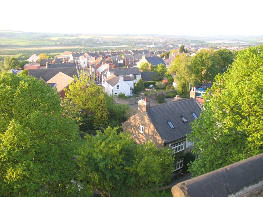
6) A more modern (May 2008) view of Brimington village centre, from the church tower, this time looking in the opposite, northern, direction. High Street stretches out, left of centre, whilst in the right distance is the parish of Whittington. To the bottom is the Grade II listed ‘pre-school private, which for some years was the village post office. It was formerly thought to be a local farm house of the Heywood family. There’s still a farm building extant at the top of Heywood Street which is named after this once important Brimington family. (Philip Cousins)
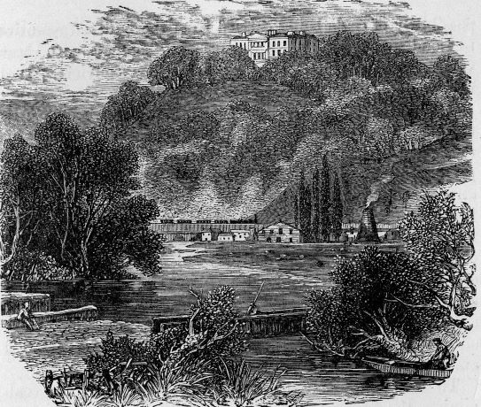
7) A relatively unknown engraving which appeared in Samuel Smiles’ ‘Lives of the Engineers’ biography of George and Robert Stephenson. This is taken from the 1879 edition, but was presumably in earlier editions. We have only used a portion in our banner, but have reproduced the whole engraving here. It is actually captioned ‘Tapton House’ – but the house is obviously out of scale with the rather romantic depiction of the scene!
Presumably the steam locomotive with train is meant to indicate the North Midland Railway, opened in 1840, which runs though both Tapton and Brimington on its way to Leeds via Rotherham Masborough. The large building to the centre is probably a former malthouse, along with (possibly) the former chemical works, the latter of which was situated in an area between the Chesterfield Canal and river Rother at Mill Green (which was also the site of a former mill).
Although the engraving is perhaps a little confusing, the person to the extreme left may be sitting on the entrance to the original Chesterfield Canal wharf of 1777. The historic course of the river Rother is the boundary between the township of Tapton and Chesterfield hereabouts.
This area would have changed considerably when the Midland Railway opened its direct line to Sheffield in 1870 and the Great Central Railway (GCR) opened its loop line in 1892 – cutting off the original wharf. The GCR ran through Brimington and there was a station at the bottom of Wheeldon Mill. We traced the history of this line and the station in Brimington and Tapton Miscellany 3.
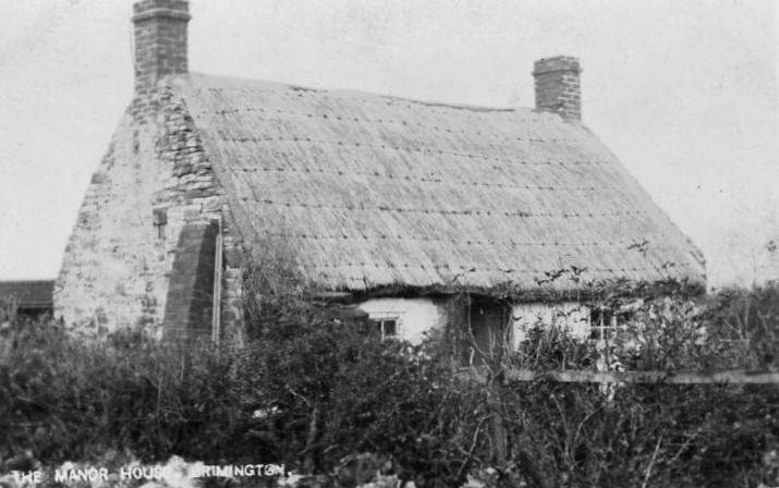
8) Though this Edwardian postcard proclaims ‘The Manor House, Brimington’, this humble dwelling is obviously nothing of the sort. It stood until sometime after 1955 where number 100 Manor Road now stands. Local tradition, recorded in the 1920s and 1930s, stated that this dwelling was built on the site of the former manor house. What most local people now call the ‘Manor House’ – the Grade II listed number 76 Manor Road – is more likely a former farm associated with a manor house (it was formerly called Manor Farm). Throw into the equation the existence of Brimington Hall and we have, perhaps, another contender for the site of a manor house! There’s a short newspaper extract about the above cottage available from our downloads page, from c.1955. The cottage marked the start of Brimington Common. It was latterly the home of the district nurse.
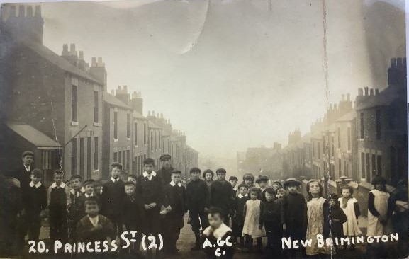
9) Down to Princess Street, New Brimington, for this Edwardian postcard – the number 20 denotes it was part of a series. Presumably parents of the children might be suitably impressed and buy copies! The 1876 Ordnance Survey map shows New Brimington being laid out, but not fully developed. Local historian Vernon Brelsford, in his 1937 ‘History of Brimington…’, tells how New Brimington was laid out – Victoria Street being the first street so constructed. Here the majority of houses were owned by the nearby Staveley Coal and Iron Company. Princess Street was opened out as part of a new road constructed from Queen Street (in the extreme distance) to High Street. Until this time there was no direct vehicular access from the bottom of New Brimington. At one time all the kerb edgings in New Brimington were of iron cast in the Staveley company works. Unfortunately they were removed in the 1970s and none survive. The Staveley Coal and Iron Company was once a major employer in the parish and its enigmatic Chairman and Managing Director, CP (Charlie) Markham (1865-1926), a major figure in the area’s industrial, social and political life.
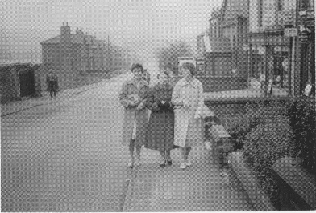
While we’re in New Brimington let’s pop down to Victoria Street, probably in the late 1950s. We don’t know who the people are in the foreground (perhaps you’d let us know if you do), but this view shows the former terraced housing, demolished in the early 1970s to the left-hand side. To the right is the former beer off-licence, where, perhaps at one time, you might pop in and get your jug filled with Stones’ Cannon ales. Immediately to the right (mostly out of picture) was a newsagent. Just beyond the off-licence is Mount Tabor Primitive Methodist Church, first opened in 1881. This church is, of course, still open, though there are now no shops in New Brimington at all.
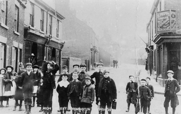
10) Another Edwardian postcard – this one of High Street. To the right, on the corner of John Street, is the general provision merchants business of Henry Phipps. A ‘self-made man’ he rose to become an alderman and the ‘father’ of Chesterfield Rural District Council and was also a parish and county councillor. Phipps purchased the Openholes, near Westwood in 1938 and presented this to the parish council. To the left are the premises of ‘T Starbuck, Fruiterer’ next is Albert Land’s grocery shop. Starbuck’s later moved to be replaced by A Derbyshire Ltd. who were drapers. Lands, who established the shop in 1899, continued until they sold out to the present shop owners – Birdi – in 1984. This shop appears to have closed in 2024.
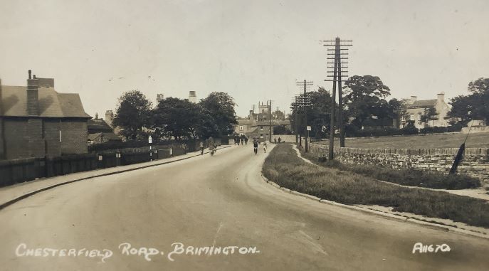
11) This 1930s view of Chesterfield Road looking towards the centre of Brimington would be hard to replicate today, if only for the lack of traffic! To the right is the farmhouse of Grove Farm. For many years the Creswicks farmed from here. The field to the right was known as Creswick’s field and hosted the fair until the early 1970s and events such as the hospital committee demonstration. It was only built on in the early 1990s. To the centre you might be able see a cottage, which is at the bottom of Hall Road just beyond is the Red Lion public house. The cottage has gone, but the pub remains.
12) An image only some 30 years before our previous one. The small cottage at the end of Hall Road, we mentioned previously, is to the right. Behind it, the tall dark building is the Brimington branch of Chesterfield grocers E Woodhead & Sons. The Ark Tavern public house (a former Methodist meeting house), is to the left and is followed by the Red Lion public house. Devonshire Street (leading to Station Road and Wheeldon Mill) turns down out of view, in front of the Red Lion. After the small shop, which appears to whited-out windows is Hunters, who were tea dealers, having shops throughout the area. They also offered an early version of dividend stamps. Their premises are currently a pharmacists. (Courtesy the late Alan Sharp).
13) The former National School building, was situated opposite the parish church, on Church Street. Originally opened in 1840, it was demolished in 1975. Essentially an organisation backed by the Church of England, National Schools could be found in many towns and villages. The building here would have become largely surplus to educational requirements when the Brimington and Tapton School Board buildings on Manor Road and Devonshire Street were opened in the 1870s. It was used by the church for many years for such things as charity distribution, Sunday Schools and other meetings. This view was taken in May 1973. At this time it was being used as a joiner’s workshop. (Courtesy the late Alan Sharp).
14) Another image that would be difficult to replicate today due to increased traffic. In this 1950s view, to the right, is the former post office and newsagents. The white building beyond is the Miners Arms public house. On the opposite side of the road, behind the railings is the recreation ground, which was given to the parish when this area of common land (hence the name Brimington Common), was enclosed by an Act of Parliament, finally ‘enrolled’ in 1853. The road which leads from Brimington to Calow was mostly laid out as result of this enclosure – the reason why it is relatively straight. This road once had three names. The village end was Manor Road, the centre section Northmoor Road and the southern (Calow end) Southmoor Road. In the 1949/50 period the whole became known as Manor Road. Record holding footballer Joe ‘ten goal’ Payne lived in this area, near the Miners Arms, which formerly had a plaque on it commemorating him. The Miners Arms closed at the end of 2022. We have a blog available detailing its history here.
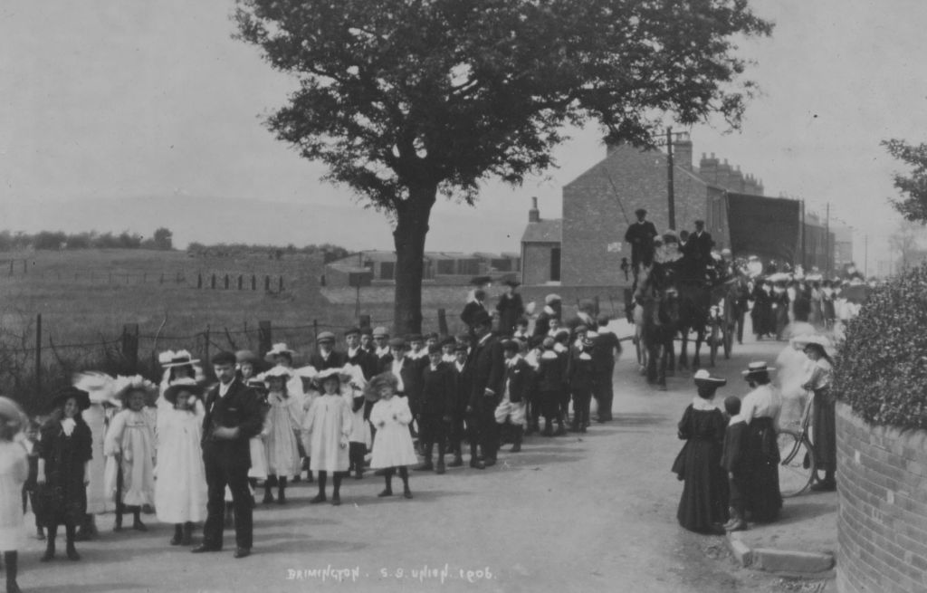
15) Our thanks to John Green for allowing us to add this postcard of the 1906 Sunday School Union procession to our gallery. The Sunday School Union was a very big event in the village at one time. Members of the non-conformist Sunday schools would process around the village and have tea and entertainment afterwards. We’ve covered the union in our Miscellany 8, which is available to purchase from us.
Of particular interest is the rather strange structure to the left of the outhouses (which are actually privy middens) to the houses on Coronation Road. We’ve zoomed in on the structure and filtered it a little in out next photograph.
16) This mysterious structure can be revealed as the remains of a brick kiln which was operating for some years on the site of what is now Eastwood Park (locally called ‘thistle park’). There’s a free download on brick-making in Brimington available from our downloads page which explains a little more about this fairly short-lived enterprise.
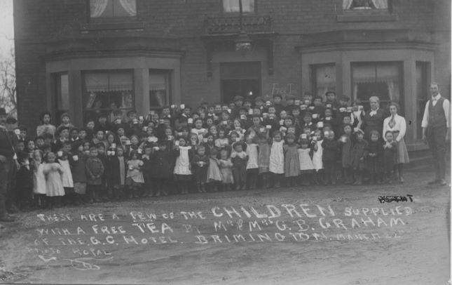
17) Any children out there need a free tea? The photograph was taken outside the Great Central Hotel, Wheeldon Mill. It shows a large group of children with attendant adults and is captioned; ‘These area few of the children supplied with a free tea by Mr and Mrs G.B. Graham of the GC Hotel, Brimington. March 22nd.’ We think this photograph was taken around 1912 as trade directories show GB Graham was licensee here at the Great Central Hotel from 1904 until last named in 1912. By 1922 Robert Britt was the licensee. You can read more about treats in the Station Road area of the village in our Miscellany 2 journal , which is available as free download.
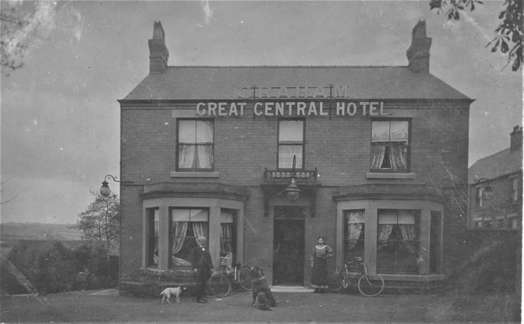
18) Thanks to our group’s secretary, Janet Walmsley, we’re able to include this splendid view of the then Great Central Hotel, Wheeldon Mill . It was posted in 1907, the recipient being a Miss Carrington of Rushstead Hous (sic), Brimington Common. The hotel was originally known as the New Inn – the name change happening sometime between 1904 and 1908. More recently it has been renamed The Mill and was probably more famous as the home of former England and Sheffield footballer Peter Swan. It was never a railway owned building. Sadly the public house closed suddenly in August 2023 and is now converted into a dental practice. We have a blog reviewing the pub’s history available here.
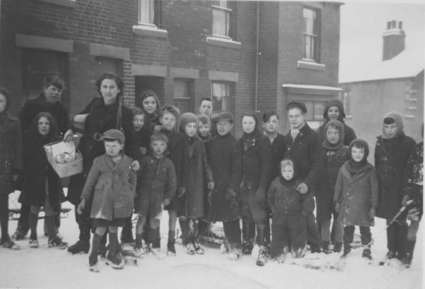
19) There’s snow on the ground in this 1950s view of Station Terrace, Wheeldon Mill. No central heating to go home to for this group. Station Terrace was across the road from the old Great Central Hotel. Backing on to the canal, they were on the land opposite Drake Terrace that’s now a car park. The terrace stood on the site of former pottery active in the 1820s and 1830s. A typical corner shop is to the Station Road end. A lorry ran into this in about 1970. As a result number 1 (the shop) and 2 Station Terrace had to be demolished. The remainder of the terrace was demolished sometime after a compulsory purchase order on them was competed in 1980. (Courtesy the late Ray Surr.)
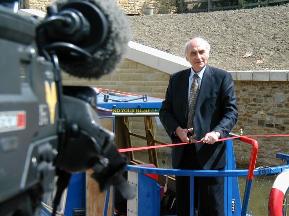
20) Brimington Division’s then county councillor Walter Burrows is being filmed by ITV’s Yorkshire Television on the official opening of the Wheeldon Mill canal bridge, 30 May 2001. He’s about the cut the ribbon allowing the first official passage of a boat under the new bridge. The bridge was culverted in the late 1960s. For many years local people saw little realistic prospects of canal restoration, but it’s now restored and navigable from commencement in Chesterfield right through to Staveley. (Philip Cousins).
21) Another view of Brimington Common, probably taken sometime after the Second World War. Photograph (14) showed the area on the horizon of this postcard, which is looking towards the village. In this view we are actually further down what was then Southmoor Road, towards Calow. The space, after what looks like fairly new detached houses on the left, would later be used for the access to a new Barry Road.
22) Over to the grounds of Tapton House and this view of Chesterfield taken from the Peace Gardens, which were opened in 1947. Unfortunately cut-backs in the planting have resulted in a much reduced bedding scheme than that depicted here. You can find out more about Tapton House in our free joint publication available from our downloads page. Look for the ‘George Stephenson and Tapton House publication’.
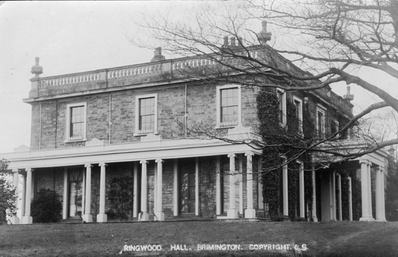
23) We need to put the record straight – Ringwood Hall (depicted here in this Edwardian postcard) is not in Brimington but nearby in Hollingwood, actually in Staveley parish! Though it’s pretty near to us – standing near the parish boundary. It’s a fortunate survivor, now a busy hotel, spa and leisure facility – and the venue for countless weddings. The hotel’s website describes it as a manor house – which it was not. It was first built by GH Barrow who leased Staveley Works, in the early 1800s. There used to be a history of the building on the hotel website disappeared., but we’ve a blog looking at its history here. Industrialist Charles Paxton Markham later made it his home. Chesterfield and District Civic Society have marked this with a blue plaque on the building. Read more about this here. For many years it was used as staff (monthly paid) facility for Staveley works. Ringwood park and lake was formerly part of the parkland to Ringwood Hall.
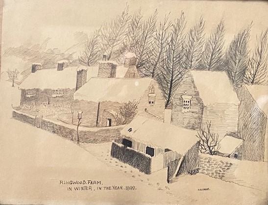
24) Ringwood Farm isn’t in Brimington either – but we couldn’t resist publishing this near the parish border view of the farm in 1899, recently discovered by one of our members. We don’t think it’s seen the light of day for a long time. The artist is HH Harvey, of whom we know nothing. Ringwood Farm still survives, though we think the majority of these buildings were replaced many years ago. The farm (and its land) eventually became owned by the Staveley Coal & Iron Company. (Courtesy the late Alan Sharp).
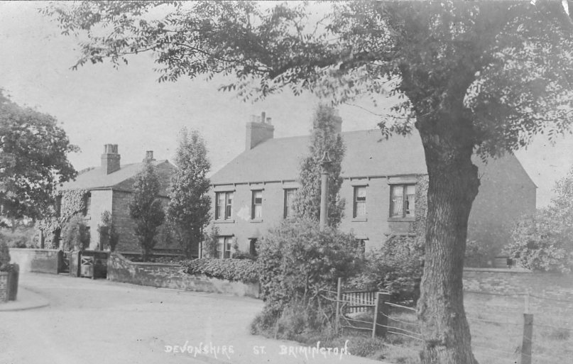
25) This view looks surprisingly rural, but in fact it’s just off the centre of Brimington, at the bottom of Devonshire Street. Immediately off to the right of this Edwardian postcard is Station Road. To left, again out of sight, would be the pair of Brimington Central (later junior) School houses. All the houses in the view have survived. We have blogged about the left hand house to the short-block of brick terraced houses – as it was the former residence (in the 1960s) of Bill Carter. He owned a Rolls Royce and may have played regularly for comedian Ken Dodd. The column in the centre of the photograph is likely to be a vent for the underground sewage system.
Our thanks to Brian Heathcote for allowing us to reproduce the next two` photographs.
26) This late 19th-century view (not a postcard) has an old typescript description Sellotaped to the bottom (which we have cropped out here). This reads: ‘Rose Cottage, Ringwood Road, the home of Joseph and Mary Cropper at present occupied by Alan Wetton, also showing the ‘Top Yard’ where now stands Wetton’s Garage and the shops. In the distance, the site of the old toll bar. The boy is Charles Cropper, for many years choirmaster and trust secretary.’ The latter description would refer to Charles Cropper’s work at the old Bethel Primitive Methodist Chapel, situated roughly opposite. Alan Wetton was the proprietor of the funeral business still with us today. Long gone (unfortunately) is Rose Cottage itself.
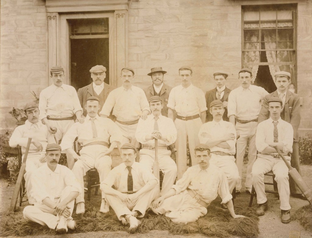
27) Brimington was an important community for supplying Derbyshire cricketing talent in the 1880s. This photograph shows the Bethel Methodist Cricket Club, with left to right, back row: Cliff Cropper, Jim Cropper (?) Hudson, W Brelsford, C Doe, W Martin, M Cook, I Clark; centre: W Twelves, C Cropper, W Bennett, G Murkin, W Mayfield; front: J Bower, D Bradshaw, C Tissington. It was originally thought that this photograph was taken outside Rose Cottage, but comparison with the above picture shows it is not – so the location is not known. There are some familiar local families represented here – not least the Croppers.
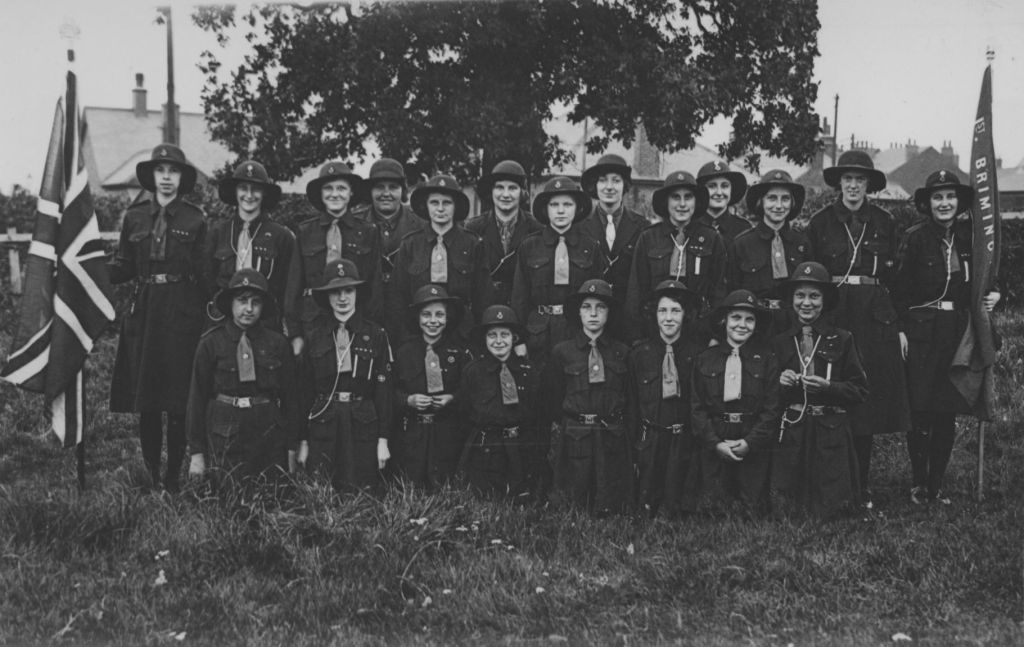
28) 1st Brimington Guides photographed in 1937 by JS Walker, Brimington. This may have been taken in grounds of Walker’s bungalow on Chesterfield Road. JS Walker was a local photographer, who appears to have specialised in community events, such as as the one depicted here.
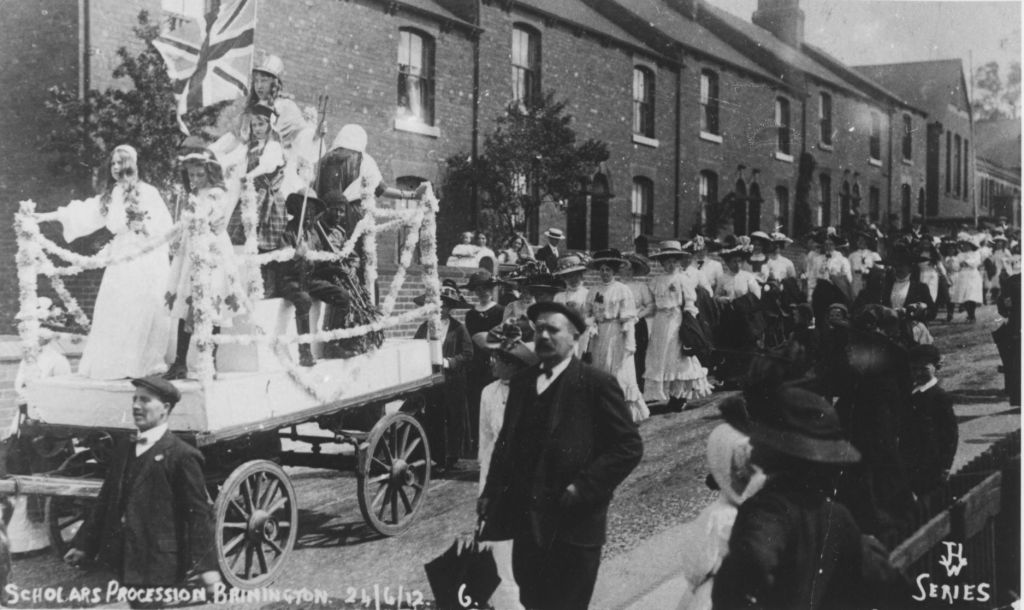
29) The 1904 opened Princess Street Infants’ School (now Henry Bradley) is to the top on this photograph, but we are really interested in the event depicted in this JH Waterhouse postcard.
The event is the then annually held Sunday School Union procession, when all the non-conformist Sunday Schools in Brimington parish would process, with decorated floats, around the village. Even the streets, at one time, were also decorated. Generally, tea and entertainments were also held as part of the events, a high-light of the year in the village.
The event pictured here was held on 24 June 1912 and was well-documented in the Derbyshire Times a few days later. A total of 960 scholars and 100 teachers took part in the procession. The float here was designed by the Mount Tabor Schools, New Brimington. It represented ‘Britannia and the Colonies’ and featured Elsie Land (as Britannia), Phyllis Musgrove (England) Madge Northern (Scotland), Annie Sharman (Ireland), Edith Wells (Wales), Albert Kay (Canada), Edwin Wright (South Africa), Elsie Phillips (India) and Ernest Starbuck (Australia). According to the newspaper other floats depicted an aeroplane, a thatched cottage, education and a decorated maypole. We have written extensively about the Sunday School Union in our Miscellany 8. The procession was discontinued in the 1930s – trips to the seaside being substituted.
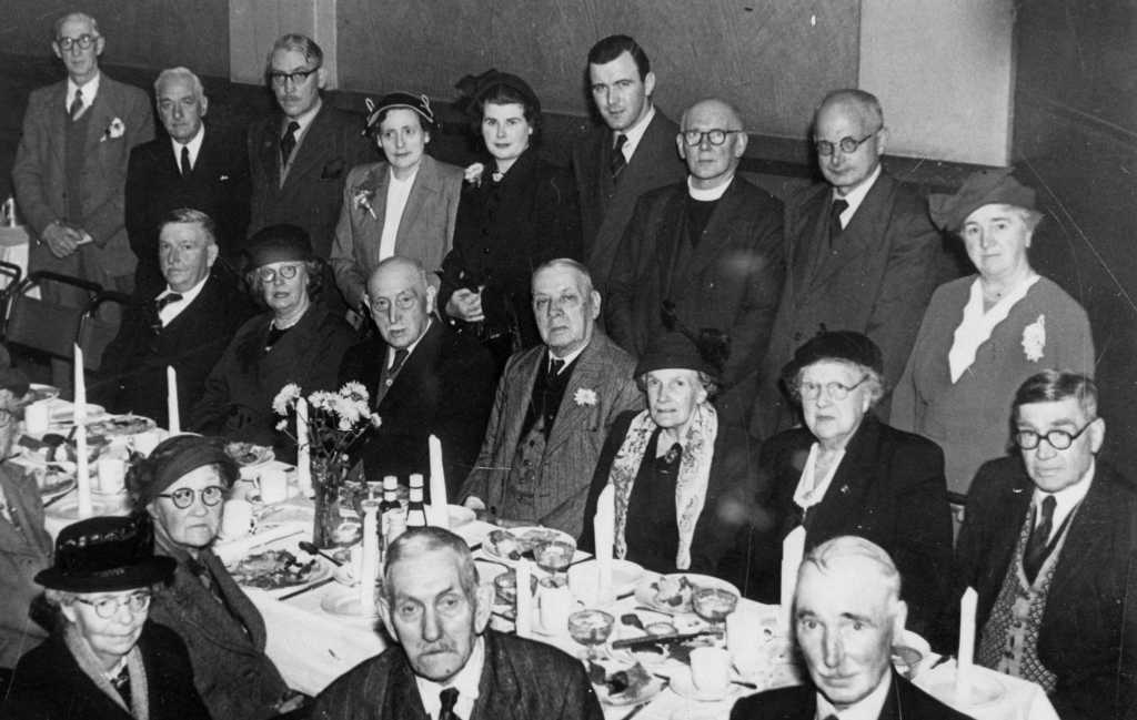
30) Probably taken in the Church Hall is this undated photograph of one of Brimington’s annual Old People’s Treats. We think that one of village’s doctors – Dr Ryan – is standing sixth from left, with his wife standing to the left. Dr O’Daly is standing third from left. He lived at Sutton House which is next to the Ark Tavern, where he also had his surgery. The man at the bottom right is a Mr. Clarke who lived on Burnell Street. There’s a possibility that Rev GIJ Cushing, who was superintendent Minister for the Staveley Methodist Circuit during the early part of the 1950s, might be the gentleman in the dog collar.
The treat was first formed in 1926 mainly from people who had worked in a committee formed that year to relieve hardship caused by the general strike. The first treat was held in January 1927. With a few breaks the treat was held since that time until its final trip in 2013. We’ve briefly written about the treat in our Miscellany 6 and Brimington doctors in our Miscellany 4.
Thanks to members of the Brimington and Brimington Common Memories Facebook page for help with identification.
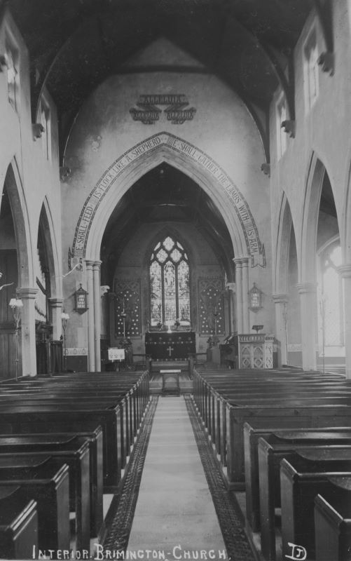
31) This splendid view is of Brimington Parish Church’s interior. Notice the wall paintings and absence of the war memorial of 1921 to the right. The stained glass to the rear of the altar is to the memory of Mrs Francis Mills (1817-1893) formerly of Tapton Grove. The organ (to the left) is a bit of a mystery. According to church and organ histories the first recorded one was of 1922 when a Brindley and Foster build was moved to the church from St Ambrose, Westbourne, Bournemouth. So, with the organ said to date from 1922 and the war memorial of 1921, just what is the date of this photograph? It’s no mystery, though, that in 1960 a decision was made to remove the Brindley & Foster organ and replace it with a much smaller Allen chamber organ. This was actually a historic unit being built in 1797, but proved, unsurprisingly, inadequate. This was sold, being replaced in 1981 by a redundant organ from the United Reform Church, Basford, Nottingham by C Lloyd & Co. This organ – the present instrument – is back in the position shown in this postcard, was completely refurbished in 1999. Our thanks to John Green for permission to reproduce this postcard.
32) Another view of the church interior. We believe that this actually shows the war memorial (on the right) straight after its dedication in 1921. At that time it stood on a rather large (5 ½ feet tall) stone plinth. The memorial sculptor was Charles Sargeant Jagger (1885-1934), who was the subject of an exhibition at the Imperial War Museum in 1985. He executed many such memorials and larger works. The figure is symbolic – a design which Jagger reluctantly produced. It was paid for by RF Mills of Tapton Grove. The figure was later removed to an adjacent wall along with the memorial slabs. The Allen chamber organ latterly occupied its site. (Collection P Cousins).